How 3,000 returned servicemen cut a 240 km coast road, what makes its cliffs and bends demanding, and where the best-known stops lie.
The Great Ocean Road is a 240-kilometre coastal road in Victoria from Torquay to Allansford, built by about 3,000 returned servicemen between 1919 and 1932. It is the world's largest war memorial. The speed limit varies from 50 to 100 km/h, and the route passes Lorne, Apollo Bay and the Twelve Apostles.
The Great Ocean Road is the largest war memorial in the world, and you can drive it. About 3,000 returned servicemen built it, mostly by hand, between 1919 and 1932, along a coast that had been reachable only by sea or rough bush track.
How long is the Great Ocean Road?
The road covers 240 kilometres (150 mi) of Victoria's south-eastern coast. It starts at Torquay, at the Surf Coast Highway, and runs west to finish at Allansford, near Warrnambool, where it meets the Princes Highway. It is listed on the Australian National Heritage List, to which it was added in 2011.
Along the way it passes Anglesea, Lorne, Apollo Bay and Port Campbell. It is a two-lane road, one lane each way, and the speed limit varies between 50 km/h and 100 km/h. Its labels have changed over the years: State Route 100 in 1986, then B100 in the late 1990s. Since 2004 it has been Arterial #4890 under VicRoads.
The Great Ocean Road is the largest war memorial in the world, and you can drive it.
Why was the Great Ocean Road built?
The plan grew out of the end of World War I. William Calder, chairman of the Country Roads Board, asked the State War Council for money to put returned soldiers to work on roads in thinly settled parts of the Western District. A road along the coast would link isolated settlements and become a vital artery for the timber industry and for tourism.
Surveying began in 1918 under the working title South Coast Road. The first idea was to run it from Barwon Heads in the east, around Cape Otway, and on to a point near Warrnambool. That same year a private company, the Great Ocean Road Trust, was formed with Howard Hitchcock as its president. It raised 81,000 pounds from subscriptions and loans, and Hitchcock gave 3000 pounds of his own. The plan was to charge drivers a toll until the debt was cleared, and then give the road to the state.
How was the road built?
Work began on 19 September 1919. The advance survey party pushed through dense scrub at around three kilometres a month, and the builders followed with explosives, picks, shovels, wheelbarrows and a little small machinery. It was risky work, and several men died. The last stretches, cut into steep coastal cliffs, were the hardest.
Daily life in the camps was plain. Pay was 10 shillings and sixpence for an eight-hour day, with a half-day on Saturdays. Men slept in tents and ate in a communal dining marquee, where food cost up to 10 shillings a week. Even so, the camps had a piano, a gramophone, games, newspapers and magazines. According to a story in ABC archives dating from 1982, workers carried their detonators on their knees while travelling, because that gave the explosives the softest ride.
Another tale concerns the coastal steamer Casino, which hit a reef at Point Hawdon in 1924 and ran aground near Cape Patton. Legend says road workers salvaged 500 barrels of beer and 120 cases of spirits from the wreck and took an unplanned two-week break. Museums Victoria says only that most of the cargo, largely Christmas goods, was thrown into the sea. The Age reported that the unfinished road had at least helped the passengers reach a farmhouse near Apollo Bay.
How and when did the road open?
| Date | Milestone |
|---|---|
| 1918 | Surveying starts and the Great Ocean Road Trust is formed |
| 19 September 1919 | Construction begins |
| 18 March 1922 | Eastern View to Lorne section officially opened |
| 21 December 1922 | Section reopens after further work, with tolls |
| November 1932 | Lorne to Apollo Bay finished, completing the road |
| 2 October 1936 | Road handed to the State Government and tolls removed |
| 2011 | Added to the Australian National Heritage List |
| December 2020 | Great Ocean Road and Environs Protection Act 2020 takes effect |
The first section had a stop-start debut. It opened with celebrations on 18 March 1922, closed again on 10 May for more work, and reopened on 21 December with a charge to recoup costs. At the Eastern View toll gate a motor car paid two shillings, and a wagon with more than two horses paid 10 shillings.
The completed road was opened in November 1932 by Victoria's Lieutenant-Governor, Sir William Irvine, at a ceremony near the Grand Pacific Hotel at Lorne. Hitchcock had died of heart disease on 22 August that year, yet his car still followed the governor's in the procession. He is generally regarded as the Father of the Road, and a memorial to him stands at Mount Defiance near Lorne. The deed went to the Victorian Premier at the Cathedral Rock toll gate on 2 October 1936.
What makes the Great Ocean Road a driver's road?
It is a narrow coastal road shaped by the land. Much of it hugs the shoreline, east of the Otway Ranges along the Surf Coast and west of Cape Otway along the Shipwreck Coast, with long views over Bass Strait and the Southern Ocean. It passes rainforest, beaches and cliffs of limestone and sandstone, which are prone to erosion.
The stretch nearest Torquay follows the coast closely, with sheer cliffs on the seaward side, and signs warn drivers of possible rockfalls. At its start, the road was thought a formidable drive that comfortably took one vehicle at a time. On the cliff sections there were few places to pull over for oncoming traffic, so for 5 pounds a public-spirited citizen could ask for a crossover to be cut. In 1962 the Tourist Development Authority judged it one of the world's great scenic roads, yet it remained challenging enough for the Victorian Police motor school to use for training around 1966.
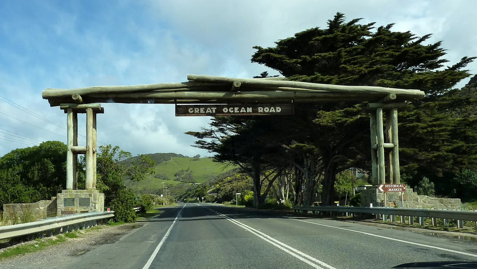
The memorial arch at Eastern View tells a rougher story. With timber logs set on a stone base, it was opened on 4 November 1939 in honour of W.T.B. McCormick, it was rebuilt in 1973 when the road was widened, again in 1983 after the Ash Wednesday bushfires destroyed it, and once more after it fell in a storm in 1990.
What are the best stops on the Great Ocean Road?
Port Campbell is the centre of the best-known sights. Rock formations carved from limestone and sandstone make the town notable: the Twelve Apostles, London Bridge, The Grotto and Loch Ard Gorge. The towns of Anglesea, Lorne and Apollo Bay make natural pauses along the way.
The Great Otway National Park spreads across 103,185 hectares (254,980 acres) about 162 kilometres (101 mi) south-west of Melbourne, covering both coast and hinterland. You reach it through Apollo Bay, Forrest, Beech Forest or Princetown. Mount Cowley, at 670 metres (2,198 feet), is its highest point, and walking trails lead through beaches and forest. The park has camping at Johanna, Aire River and Blanket Bay, plus a significant koala population around Aire River.
Cape Otway Lighthouse, next to the park, is open to visitors all week. Southern right whales, southern humpbacks and bottlenose dolphins can be seen from the coast. After dark, glow worms shine along stream banks and tracks. Good places to look include Beauchamp Falls, Hopetoun Falls, Stevenson Falls, Melba Gully and Angahook-Lorne State Park. The ghost fungus on trees glows pale green at night, too.
The park itself is relatively young. It was declared in 2004 by combining Otway National Park, Angahook-Lorne State Park, Carlisle State Park, Melba Gully State Park, part of the Otway State Forest and several Crown Land reserves, and was officially gazetted on 11 December 2005, after a campaign by the local community. BirdLife International has named it an Important Bird Area, since it supports rufous bristlebirds, striated fieldwrens and pink robins. The Atlas of Living Australia lists two hundred and seventy-eight species of fungi there, which is probably only a fraction of the total.
Walkers have an alternative to the road itself. The Great Ocean Walk, opened in 2004, links 104 km of trails that follow the coast from Apollo Bay to the Twelve Apostles.
How many Twelve Apostles are there?
Seven of the original nine stacks still stand. The name was made official to attract tourists, even though there were only ever nine, and it may be that there never were twelve. Six stacks can be seen from the most popular viewpoint, and the seventh stands several metres from the corner of the main viewing platform. The formation was once called the Pinnacles, and also the Sow and Pigs.
Erosion made them. Weather from the Southern Ocean wore the soft Port Campbell Limestone, laid down some 15 to 5 million years ago, into caves, and the caves became arches. Arches fell, leaving stacks up to 50 m (160 ft) high. A 50-metre-tall (160 ft) stack collapsed in July 2005, leaving eight, and another went in 2009. Waves continue to work on the base of each stack.
In March 2023, the Federal Court ruled that the Eastern Maar people are the traditional owners of 8,578 km2 of south-west Victoria, an area that includes the Twelve Apostles.
What should drivers know about weather and closures?
The Great Ocean Road has been shut by nature several times. Storms washed away part of the section at Princetown in 1960. Landslides closed sections near Lorne on 11 August 1964 and again in 1971, bushfires closed the road in 1962 and 1964, and in January 2011 heavy rain brought down part of a cutting.
The Otway Ranges behind the coast are among the wettest places on the mainland. They record 219.4 precipitation days, the most in mainland Australia, narrowly ahead of Mount William's 215. Heavy snow falls on the higher peaks each year, and wet snow has occasionally fallen close to sea level. Logging, which began in the 1880s and peaked in 1961, almost entirely stripped the ranges of their old-growth forest. The last major fire there was part of the Ash Wednesday bushfires of 1983.
Which events use the road?
A 45-kilometre section between Lorne and Apollo Bay hosts the Great Ocean Road Marathon, part of the Great Ocean Road Running Festival, which was first held in 2005. Englishman Nick Earl holds the course record of 2:27:37, set in 2019. He beat 2:27:42, set in 2011 by James Kipkelwon of Kenya, who also won in 2012.
Cyclists have their own events. The Cadel Evans Great Ocean Road Race includes elite races and a mass-participation People's Ride, which as of 2019 offers distances of 35 km, 65 km or 115 km. Each September, Amy's Gran Fondo uses the section between Lorne and Skenes Creek. The event is among the very few in Australia held on a fully closed road, and it is named for Amy Gillett, who died in 2005 after a collision between the Australian women's squad and a driver in Germany.
Where this goes next
The road gained legal protection in December 2020, when the Great Ocean Road and Environs Protection Act 2020 took effect. It also has a record of recognition: an Engineering Heritage National Marker from Engineers Australia, and a first place in the Royal Automobile Club of Victoria's 2008 Victoria 101 survey of the state's top tourism experiences.
Nature will keep changing the coast. Wave action is eroding the cliffs, and the existing headlands near the Twelve Apostles are expected to become new limestone stacks in the future.